September 2024 was the second-warmest on record globally and for Europe, according to the latest report from the EU’s Copernicus Climate Change Service (C3S).
The average global surface air temperature in September 2024 reached 16.17°C, 0.73°C above the 1991–2020 average, while sea surface temperatures also saw significant rises.
The report said the average global temperature last month was second only to September 2023.
C3S reported that September’s heat follows a 15-month period where global temperatures exceeded 1.5°C above pre-industrial levels.
“September 2024 was the second-warmest globally and in Europe,” said Samantha Burgess, deputy director of C3S.
“We are seeing more extreme rainfall events, which are worsened by a warmer atmosphere.”

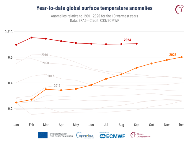
Monthly year-to-date global surface air temperature anomalies relative to 1991-2020 for the ten warmest years on record.
2024 is shown with a red line, 2023 with a yellow line, and all other years with grey lines.
Each data point shows the average anomaly from January to the corresponding month. E.g. the value for September 2024 corresponds to the average anomaly from January to September 2024.
Rising global and regional temperatures
The year-to-date (January-September 2024) temperature anomaly was the highest on record, surpassing 2023 by 0.19°C.
If global temperatures continue on this trajectory, 2024 is almost certain to become the warmest year on record, with the data indicating no significant temperature drop in the remaining months.
Europe saw its second-warmest September, with temperatures 1.74°C above the 1991–2020 average. Eastern and northeastern Europe experienced the highest temperature anomalies, while western regions such as France, Spain, and Portugal saw below-average temperatures.
Extreme rainfall and storms
September saw “extreme” rainfall and destructive storms in many parts of the world, events that are occurring with greater severity and frequency as global temperatures rise due to climate change.
Warmer air can hold more water vapour, and warmer oceans mean greater evaporation, resulting in more intense rainfall.
“The extreme rainfall events of this month, something we are observing more and more often, have been made worse by a warmer atmosphere, leading to more intense rainfall with months’ worth of rain falling in just a few days,” said Burgess.
In Asia, Typhoon Krathon caused severe damage in Taiwan and the Philippines.
The C3S deputy director explained that warmer air holds more moisture, leading to heavier rainfall.
“The risk of extreme rainfall will continue to increase with rising global temperatures,” she said.
Sea surface temperatures (SSTs) were the second highest on record for September, averaging 20.83°C.
Arctic sea ice continued to shrink, with the sixth-lowest extent on record, while Antarctic sea ice remained near-record lows for the month, at 7% below average.
In addition to Europe, regions such as Canada, the central and western US, South America, northeast Africa, China, and Japan experienced well-above-average temperatures.
Conversely, parts of the Sahel, southern Africa, and Antarctica saw below-average temperatures.
Copernicus data, based on billions of measurements from satellites, ships, and weather stations, provide critical insights into the accelerating impacts of climate change on global weather patterns.


